Wearable and carryable technologies have made a significant impact on how daily environments are navigated. As interactive maps are more commonly used and hosted on smartphones, the connections between users, technologies, and communities become more available and transparent. With more products being developed for customizable wayfinding experiences, investigating how the interaction between environment and user is being filtered and communicated through these technologies becomes increasingly important.
One such method of investigation is considering mapping technologies as designs that are not only rhetorically informed, but also designs responsible or reflective of the wayfinding techniques for their users. By “de-naturalizing” (Barton & Barton, 1993) how physical space is represented in technology, the wayfinding models that are produced by standardized technologies might be challenged as taken-for-granted actions, instead repositioned as processes which benefit from incorporating the diverse designs of diverse creators and users.
Here, I’ll be discussing a starting index for products that disrupt traditional approaches to mapmaking, focusing on examples of collaborative/community and multimodal maps. These products are able to highlight how wayfinding is not a neutral display or process, but sociospatially informed and composed.
“Natural” Wayfinding
Discussions of map analysis and redesign show the importance of positioning maps as malleable products in the hands of their creators and users (Hall, 2004). Mapmaking as a practice of composition demonstrates the ways in which maps speak about the norms and social influences of their creators (Barton and Barton, 1993; Harmon, 2004). When these norms are established, affirmed, and replicated by those in privilege, experiences outside of it are not always represented in mapping technologies.
An obvious area for potential silencing in maps can be found through the naturalization and homogenizing of bodies, minds, and spaces. When the default is limited to the experience of an able-bodied/minded person, the ideologies which inform the creation of maps can omit alternative, non-hegemonic needs or interactions. For maps to be more inclusive, space and environment must be conceptualized outside of dominant experiences, as should the wayfinding techniques used within them.
Wayfinding, as defined by Horton and Quesenbery in A Web for Everyone, “includes both navigation (features that let users move around the site) and orientation (identifying the current location).” For all users, the semiotics used in defining space are rhetorically constructed actions which work within larger sociopolitical climates (Denis & Pontille, 2010). Developing more technologies which include other measurements of environment aside from mainstream orientation principles can not only improve user experience, but also encourage innovative design practices for wayfinding.
Mapping as Community and Collaborative Work
One clear shift in traditional wayfinding systems brought by carryable and wearable technology is the use of mapping applications to more actively engage the community in their production. The accessibility of these technologies to a broader user base has contributed to crowd-sourced navigation. As discussed more thoroughly by Sean Kamperman in a previous post in this series, community mapping offers opportunities of resistance against the normalization and faux neutrality of environmental/community access by integrating sociospatial considerations of users.
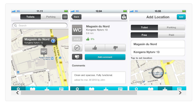
Two of the more popular products available through iTunes and Google Play are the mobile apps WheelMate and WheelMap. Both apps rely on participatory contributions from their users to mark accessibility information on community maps, such as toilets, parking spaces, and building entrances.

Reading company message boards on iTunes and Google Play, positive reviews of these products come from being able to directly compose new filters on licensed, satellite maps—providing ratings for accessible establishments and locating spaces not typically demarcated on popular products like Google Maps. The ability for users to make real-time contributions to maps allows for customizable visualizations that are inclusive of more social experiences.
It is, however, important to note the balance between community writing, participation, and product development with these types of mobile applications. Having a product reliant on user contributions has the potential for adding to, and taking advantage of, users’ intellectual labor, as noted by a customer review for WheelMate:
This app should have been pre-populated using some research by the developers, then ask users to update any errors in it, rather than just publishing it as effectively an empty database and it does not work i.e. update, when you try to populate any of the fields. It also cannot find locations properly & is not user friendly, e.g. listing towns in alphabetical order or having sub-categories for e.g. restaurants, cafes, shopping centres, retail parks, etc. I would be willing to give this app another chance & change this review, if the developer put some work in to it, because most people don’t have time to do the developer’s job for them. Cannot recommend at this time.
–User PsychicKnowHow, taken from iTunes (emphasis mine)
The framework of having community and collaborative wayfinding strategies determined by actual, diverse user bases still offers an avenue for resisting dominant, hegemonic practices of wayfinding and environmental interactions. Community-based and collaborative methods of mapping is one potential means to challenge the relationships between standardized technologies/visualizations of environment and how they are experienced by users.
Some Apps Using Collaborative or Community Work
WheelMate
WheelMap
It’s Accessible
Be My Eyes
VizWhiz
Multiple Modes of Access in Mapping
When navigation is an action informed by the interfaces used, mapping technologies which utilize different modalities can attribute to or enhance alternative methods of wayfinding. More technologies are being developed that incorporate environmental interactions and displays that are not dependent on the typical conventions of visual mapping.
Alternatives to visual mapping, such as the Ariadne GPS and voice-command features, provide navigation based on auditory directions. The Ariadne GPS in particular challenges the visual mode of the map by creating soundscapes for exploration, with different sounds to indicate areas such as parks, streets, or bodies of water.
Other mapping technologies offer additional means of portraying more honest environments for differentiated users. Products such as Light Detector demonstrate sensory information for spaces, a consideration which is rarely shown on standard maps. Other designs, such as the newly developed Challenger App for users with Social Anxiety Disorder, have been created using gamification and sociospatial considerations to assist users in mitigating and responding to stimuli in their environments (Miloff, 2015).

Technologies such as these applications are one way to start introducing multiple points of access through designed wayfinding.
Some Apps Using Multiple Modes of Access
Ariadne GPS
iMove
Light Detector
LookTel Breadcrumbs
Challenger App
When taking into account the customization of these technologies, how might new or other designs for mapping influence or shift the connections between users, technologies, and communities? Are there other ways in which environmental access becomes standardized or de-naturalized outside the use of wearable/carryable technologies? And finally, can viewing wayfinding as a rhetorically informed and designed process position it as a method of multimodal composition?
References
Barton, B. F., & Barton, M. S. (1993). Ideology and the Map: Toward a Postmodern Visual Design Practice. Professional Communication: The Social Perspective, 49-78.
Denis, J., & Pontille, D. (2010). Placing Subway Signs: Practical Properties of Signs at Work. Visual Communication, 9(4), 441-462.
Hall, S. (2004). I, Mercator. You are Here: Personal Geographies and Other Maps of the Imagination. Princeton Architectural Press, 15-29.
Hamraie, A. (2013). Designing Collective Access: A Feminist Disability Theory of Universal Design. Disability Studies Quarterly, 33(4).
Harmon, K. A. (2004). Introduction. You are Here: Personal Geographies and Other Maps of the Imagination. Princeton Architectural Press, 1-14.
Horton, S., & Quesenbery, W. (2013). A Web for Everyone: Designing Accessible User Experiences. Rosenfeld Media.
Miloff, A., Marklund, A., & Carlbring, P. (2015). The Challenger App for Social Anxiety Disorder: New Advances in Mobile Psychological Treatment. Internet Interventions, 2(4), 382-391.
